International News
Hurricane Dorian a Catastrophic Category 5 Storm. And It’s Getting Stronger.
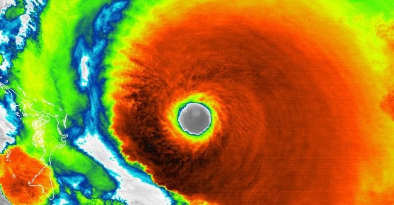
Devastating hurricane conditions are expected in the Bahamas, NASA says.
Hurricane Dorian is now a “catastrophic Category 5” storm as it approaches the Bahamas in the Caribbean, according to a National Hurricane Center update today (Sept. 1).
As of 8 a.m. EDT (1200 GMT), Dorian has maximum wind speeds of 160 mph (260 km/h) as the storm churns about 35 miles (55 km) east of Great Abaco Island, the NHC wrote in the update. The storm is about 225 miles (360 km) east of West Palm Beach, Florida.
“Devastating hurricane conditions are expected in the Abacos Islands very soon and these conditions will spread across Grand Bahama Island later today,” NASA officials said in an update.
Hurricane Dorian is currently moving west across the Caribbean at about 8 mph (13 km/h), a relatively slow speed that is expected to result in the storm dumping massive amounts of rain on the Abaco Islands. Dorian is expected to slowly move west over the next two days before turning northeast.
“On this track, the core of extremely dangerous Hurricane Dorian should be moving over Great Abaco soon, and continue near or over Grand Bahama Island later tonight and Monday,” NHC officials said in the update. “The hurricane should move closer to the Florida east coast late Monday through Tuesday night.”
NASA’s Kennedy Space Center, in Cape Canaveral, Florida, has taken steps to safeguard itself against Hurricane Dorian. On Friday (Aug. 30), center officials moved a massive 400-foot Mobile Launcher tower into the shelter of the center’s 52-story Vehicle Assembly Building to protect it from damage.
NASA, the NHC and the National Oceanic and Atmospheric Administration are using satellites in orbit and U.S. Air Force flights through the eye of Hurricane Dorian itself to track the storm’s progress. They’ve even captured videos of the storm from the International Space Station.
“The NHC has reported that hurricane-force winds extend outward up to 30 miles (45 km) from the center, and tropical-storm-force winds extend outward up to 105 miles (165 km),” NASA officials wrote in its update. “Elbow Cay in the Abaco Islands just reported winds of 35 mph (56 km/h).”
NHC officials warned that Hurricane Dorian’s path could change. The storm’s eye is currently forecast to remain offshore as the storm moves up the U.S. East Coast from Florida to Georgia, and then on to the Carolinas. Dorian’s powerful winds should reach the eastern portions of those states.
SOURCE: LIVE SCIENCE